Mapollage is a Java tool that can be used to put your geotagged photos on the map by creating an KML file that can be used with Google Earth.
Here's a quick demo of a KML file I created using Mapollage, loaded in Google Earth for Linux:
Mapollage features:
- Create kml folders by directory name, date pattern and regex;
- Placemark names can be set to filename and date pattern;
- Placemark symbol can be set to pin or photo, with customizable scale and zoom;
- Dynamic description generator;
- Customizable photo reference and size;
- Draw path between placemarks.
The application was updated to version 1.0.4 recently, bringing options to rotate thumbnails, add .jpg extension to thumbnails, as well as a filter that allows excluding file paths using a filter.
To use Mapollage, you'll need Java 8 (both OpenJDK and Oracle Java 8 should work), and obviously, geotagged photos. If your photos are not geotagged, there are various tools out there to do this manually, like ExifTool (here's a quick guide for geotagging photos using ExifTool).
Running Mapollage in Linux is fairly easy. Either directly double click the .jar file or right click it and select Open With > Oracle Java 8 Runtime or OpenJDK Java 8 Runtime.
Note that for OpenJDK, you'll need to make the file executable (with Nemo / Nautilus, right click the file, select Properties, then on the Permissions tab, enable "Allow executing file as program").
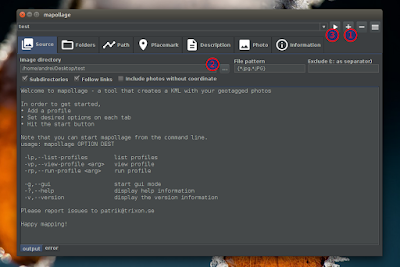
Once you start Mappolage, create a new profile (1), add a folder (2) containing geotagged photos and click the start button (3) to generate a KML file:
You can change the placemark symbol (photo / pin) and name (filename / date / no name) from the Placemark tab.
That's it. The newly created KML file can now be opened with Google Earth. Your photos should show up under Temporary Places, as you can see in the Google Earth screenshot above.
Download Mapollage
Arch Linux users can install Mapollage via AUR.
To report bugs, download the source code, etc., see the Mapollage GitHub page.


